
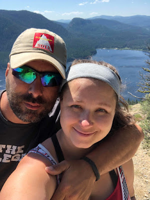

My wife and I made the 5.8 mile R/T hike up to Point 4590. This is a great hike in the Kalispell area and gives way to great views as can be seen from below. There is also a trail that continues on down to the lake as seen from the map below. The trail has been well maintained. We have been to the area now on two different occasions with not many people there. Today we ran into a group of two hikers and a mountain biker came to the top while we were up there. This is a fairly long hike for a 1 Point SOTA summit but if you are in it for more then SOTA it is a great choice. For those of you that do Geocaching there is also a geocache just off the trail and before the summit. The view from below in only about 30 ft off of the summit so is well within the activation area. The summit has a good amount of trees and there is not much of a view. This summit is probably not a good choice for those collecting points but it is a good hike with a great view...and worth the hike to be the first to activate.


 |
| I tracked our hike with my Garmin on the way up. The GPX tracks can be found here: https://www.dropbox.com/s/ym8gatbu9kjgilm/Track_2018-07-21%20135244.gpx?dl=0 |
Driving GPS Tracks (Click Here)
 |
| I spent a good deal of time trying to Call and also tried 17m SSB, 20m CW, 40m SSB. With no luck. Not sure what was going on today. |

Equipment:
Elecraft KX2 with KXPD2 and internal battery. MP1 Super Antenna, Kenwood TH-D72 for 2m and APRS.
Cell Signal(Verizon):
I use had decent cell phone signal from the summit. I spotted a few times using SOTA Goat and was able to spot with out any issues. LTE/3G signal most of the time.
Trail Conditions
5.8 Miles on a well maintained single track trail. Shared with Horses, Bikers, and Hikers.
Fees:
None
APRS (Kenwood TH-D72):
I did my initial spot using APRS. I like to keep proficient in these uses. It was a good thing that I did it as it took some getting used to again.
GPS Tracks:
https://www.dropbox.com/s/ym8gatbu9kjgilm/Track_2018-07-21%20135244.gpx?dl=0Hiking Tracks
Driving Directions:
From Kalispell, Farm to Market Road, Tally lake Road, FR2924
Band Conditions:
I was not able to work near as many stations as I am used to. Band conditions were not that great but I was able to get a few contacts. Two of my normal contacts N4EX and W0MNA were not able to make the contact. I could here them fine but was not able to complete the contact on my end.
Summit information and resources used for planning
I use this app to estimate distances of new trails.
Here is one of my secrets!!! Even if you don't do geocaching take a look at the map. If you manipulate it right up can see every summit out there. If there is a geocache at the top, there is a way to get there. Sometimes if you click on the cache it will even give detailed directions to get there and some good pictures.
Here is an example of some decent directions learned from a geocache. The information was out dated but much of the time it is not.
http://www.cqgma.net/mvs/index.php
Adventure Radio Map View - I like this map as a way to see the summits. It seems more user friendly with filters then the SOTA mapping software.
http://www.nohrsc.noaa.gov/interactive/html/map.html
NOHRSC Interactive Snow Information - This is a great tool to see where the snow levels are and what they have looked like in the past on certain dates.
http://www.gpsvisualizer.com/draw/
Put in a route in this site and it will give you a gps file for the information you provide. This works if you want to draw and upload a route into your GPS for use on the trail.
Way to go Matt!
ReplyDelete