Wild Horse Mountain SOTA (W7M/FS-180)


Date: 23 June 2022
Summit Name: Wild Horse Mountain
Summit Coordinates: 48.05624, -114.39098
Distance: 5 miles round trip Start Elevation: 4,915
Prominence: 510' Summit Elevation: 5,210'
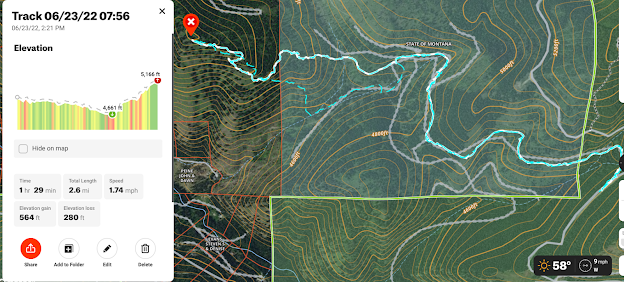
Elevation Gain: 564' Elevation Loss: 280'
https://listsofjohn.com/searchres?textsearch=wild+horse&Search=Name&State=MT
Colten and I woke up around 6 and headed out to Wild Horse Mountain which was un-activated. We came in through the Kila area up towards Wild Bill and Emmons Creek Rd and then out through Kalispell on Patrick Creek.
We parked at the gate at 48.04903, -114.36307. The walk was about 2.5 miles each way. The walk in on the roads are great but there is no real trail to the summit. There are plenty of game trails but you really just have to make your way up and find your way. I recommend staying to the ridge on the South east side as you can follow the edge of the thick trees and follow the ridge which is slightly less steep (not much).
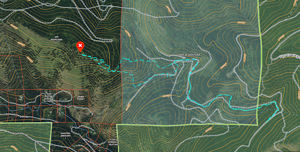
You can see that the area up to the summit is private. See below for information regarding this.
Cell Signal: There was cell service at the summit and most of the way up. I relied on the reverse beacon network for spotting (Verizon).
APRS: I was getting out location reports for almost all of the trip (Driving and Hiking). Definitely would be able to use APRS to SOTA for spots and send messages from the summit.
Trail Conditions: Road was great...have fun on the last .5 mile assent up to the summit. Hopefully you can find a good trail.
Equipment Used:
QRP Endfed Antenna 30 meters (
k6ark.com). I am going to make this a tuned multi-band antenna but I have to work on some traps. I may start bringing a tuner with me and another antenna until I can get this done. There is the possibility that I only do 30m for the near future though.
Radio Log:
 |
The highlighted track that goes to the North is the way that we hiked to the summit. I would not suggest this route as the trees on the north side of the summit are very thick and hard to get through after you enter private land.
https://huntsmarter.app.link/Pu8YrjoZ6qb
 | The highlighted route to the South is the way that we came off the summit and back to the truck. It is about the same distance and we dropped steeply off the summit but were able to avoid the thick trees and all of the side hilling.
https://huntsmarter.app.link/1nCfaVqZ6qb
|
|
 |
You can see that too the West of the State Land there is private and is labeled as "SPP Montana LLC." If you visit the website below you can see that this is permanent conservation land that was purchased "to permanently protect nearly 200,000 acres in Northwest Montana through “working forest” conservation easements." This company has bought a lot of land throughout NW Montana and it has many trails running through it. There are no signs preventing access.
Summit View on Approach Echo hanging with us.
View of Blacktail on the way down.
Thanks for Reading.
|


No comments:
Post a Comment