Recent SOTA Activations

Tuesday, December 31, 2013

Mt. Diablo (W6/CC-045) SOTA Activation

On 23 December my son Peyton and I headed up to San Francisco to work. We took advantage of 1/2 day schedule for Christmas and headed over to Mt. Diablo after getting off of work. This is the first time that I had been to Mt. Diablo but my GPS had taken me right there. I had looked at the imagery on Google maps prior to going and saw what looked like a parking area about a 1/2 mile short of the summit. We found this parking area with no problem with room for 5 or 6 cars on the side of the road. This ended up being a good idea as the parking lot at the top is small and very popular. We parked the truck and headed up the summit. We saw all there is to see at the top and then slipped off the Side a little bit to get away from the crowds. I verified that we were still in the activation area and then set the radio up. 

Route: This is an easy trip as I searched for the park in google maps on my iphone and it took me right to the summit. The park website also has a good map with trails and roads. http://www.parks.ca.gov/?page_id=517 As you can see the North Peak Trail starts right off from where I parked. This will be getting some use in the near future.


Cell Signal: Yes (Verizon). Was able to self spot on SOTA Goat and make phone calls. Most of the way up the mountain my phone was searching for signal though.

Interference: None.

Distance: Round Trip .5 mile. The every trail route will show a little longer as we did a quick recon for our follow on trip after the new year to North Peak. If you just hiked from your car to the summit it would be about 1/2 mile.

Trail Condition: Easily identifiable trail but a little loose in places and you need to watch your step.

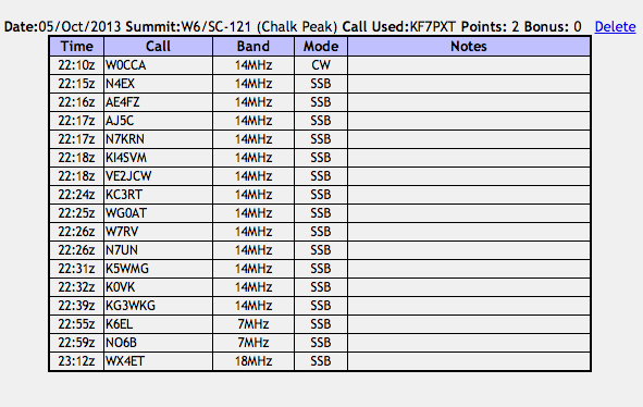
Log: I only did 20m today as I seemed to have a good short skip today and was able to get the short chasers and the long ones across the country. Was in a little bit of a hurry so left it at that. I am sorry if you were waiting for me to change bands. The next time I will spend a little more time.


The first group of Antennas that we came to.


Peyton just short of the actual summit. It was a great day for a short sleeve hike. Mid 60's at the top.


A little schack on the trail up to the Summit. Pretty well camo'd.


Lookout on the summit. This is where all the tourists go. We avoided it.There are plenty of views in other areas.


This is a picture of Devil's Pulpit, which can be seen on the map above. We hiked down and around it to get a good look at the route to North Peak.


In the last few weeks, I have been building a few kits. I have a PFR3 that is up and ready to go. I will probably start out with this on 40m and then work my way up as I feel comfortable. So my PNW chasers (K6EL & NS7P) will get to work me on CW. I will definitely get to the lower bands but it may be on SSB. I also built a Rock mite which is coming together though I am having some fun issues with that. I ordered the Super Rock Mite from China and have that a little bit assembled. My advice to you on this is DONT BUY IT! The instructions suck and a lot of parts are missing. I am hoping to have it together and working one of these days though. I am working with the seller to get some good English Instructions up on the Website. 

Thanks to all the Chasers!

73s
Matt
KF7PXT


Thursday, November 21, 2013

Black Mountain (W6/NC-150) SOTA Activation

On 18 November 2013 I hiked up Black Mountain with Curtis (KC5CW), Elliot (K6EL), and my son Peyton. Both Curtis and Elliot Activated the summit but Peyton and I did some Geo Caching while they were busy. I am still not 100% from surgery and did not carry all the equipment up the hill for an activation. I did get down out of the activation area for 2m contacts with both activators. We had dinner at Howie's Pizza and Rick (N6XI) met us there. 

Route: From Moffett Field Exit in Mountain View, CA take HWY 85 South (4.6 Miles) to HWY 280 North (6.5? miles) to Page Mill Road, Left on Page Mill Road (4.2 Miles) To small parking lot on the Right side of the road.

Cell Signal: Yes (Verizon). Digital Signal Questionable but with patience will be possible to self spot.

Interference: None.

Distance: Round Trip 4.5 Miles

Trail Condition: Well Maintained Easy to follow fire road and trail.


Setup: No rig for me. Curtis - KX3 and EndFed 1/2 wave antenna (20m).

Contacts: Curtis and Elliot log on SOTA. I had a 2m contact with each activator from outside of the activation area.

Curtis' KX3 and Battery


Curtis working the Pileup


End Fed Antenna in an inverted V over a small tree.


Peyton and I at the Marker.


Peyton at the Summit


Peyton sitting by the antenna. (Photo by Curtis)


Picture of all of us after the activation eating Pizza.


Though I did not do any activating I did have fun with some fellow SOTA activators on a summit. I am still not healthy enough to carry all my equipment up to the summit and activate but it will be soon. It was great to do another summit with Elliot and meet Curtis and Rick (N6XI). Rick was supposed to summit with us but had another situation come up that had to be dealt with. Maybe another day.

Thanks everyone for the great time and I look forward to the next time!

Tuesday, October 22, 2013

Fremont Peak (W6/CC-055) SOTA Activation

On 21 October 2013 I headed up to Fremont peak with my 4 year old son Colten and met Steve (WG0AT), and his wife Pam, for a quick SOTA activation. I brought minimal gear that consisted really of water, antenna, tuner, and my HT. I am still on the recovery plan from back surgery. My plan was to try and get enough 2m contacts with the HT to count as an activation. 

Route: From Mountain View, CA take HWY 101 South for 51 mi., CA 156E for 3.4 mi, Right on Alameda and follow signs to state park. Note: If you use a GPS Google on the phone seems to work the best. Car GPS devices tend to take you off on steep dirt roads. If you want to know more ask Steve as the rental car earned its money on this trip. This road can be take easily with about any car, even a rental!

Cell Signal: Yes (Verizon), Steve also had limited digital signal and was able to send out spots on SOTA Goat (Unknown Carrier)

Interference: None.

Distance: Round Trip 1.8 miles.

Trail Condition: Easy to follow path pretty much all the way to the top. The last 50 vertical feet is a scramble.

EveryTrail Route: http://www.everytrail.com/view_trip.php?trip_id=2317740 This is the route from my first trip up there. On this trip I actually did not track it. 

Setup: ATS4 (2 watts), 9 volt battery, SOTA tuner with 1/2 wave wire on 20m.

Contacts: 4 Contacts for me (Below). These were very tough contacts. It took me a lot of concentration on the Morse Code.  I know that Steve got quite a few contacts as well


Screen shot of my log. This is the shortest log that I have ever had but the hardest worked for. I apologize if you called and I did not respond. It was a work-in progress!


Colten and I on the way up to the Summit. (Photo by WG0AT)


Here is the Rig. (Photo by WG0AT)


A view of me trying to get CW contacts. I think that part of my problem was that I can send code significantly faster then I can copy! I was able to get Phil (NS7P) fairly easy. Maybe this is because I am so used to hearing his call. As of this summit Phil has chased me 24 times! My most loyal Chaser. Thanks Phil! (Photo by WG0AT)


Steve showing me how it is done!


Colten making guarding the summit...and eating trail mix! (2nd Photo by WG0AT)


On the way off the Summit talking with Pam. Thanks Pam for your patience with us while I was trying to get my 4 contacts!!!  (Photo by WG0AT)


A Photo of me working CW. (Photo by WG0AT)

This is how I really felt and what I had waiting in my Email when I returned home! Thanks Steve for the great time, motivation, and experience! See you in Colorado one of these days!  Photo by WG0AT.


Thanks to all my very patient chasers. In time you will hear the CW improve greatly. More CW activations to follow!


Wednesday, October 9, 2013

Chalk Peak (W6/SC-121) SOTA Activation


 On the 5th of October I took the kids out so mom could work on some school work in peace and quiet. This was a great trip out. On the way there Brookelyn got sick. I originally thought that it was car sickness and thought that a little walk would help her out. The whole time that we were at the summit she was throwing up so I cut the activation a little short and headed back down to the truck. As it ends up the bug made its way around the entire family. I think that it is over now though.

Route: HWY 101 South to King City, CA. The rest of the directions are below. On the way back we continued over Nacimiento-Fergusson Rd and down to HWY 1 North back to the bay area. A long trip but a lot of fun.

Cell Signal: Yes (Verizon), Signal was in and out but I was able to get some spots out.

Interference: None

Distance: Less then 1 mile.

Trail Condition: Break Brush to the top

EveryTrail Route: No route. All but the last couple hundred feet (vertical) was drive up and pretty much breaking brush to the summit. I think that approaching from the south west and following the ridge up is the best approach.

Setup: FT857d, Home made End Fed on 20m, MP1 SuperAntenna, 3 Counter poises at 1/4 wavelength, 12 ft telescoping whip on 40m, 7.5 A/H SLAB.

Contacts:


I did not get any pictures from the actual summit as I was dealing with a sick kid. I thought that Brookelyn was car sick from the trip up but it seems that after the trip home and multiple episodes that she had a stomach bug. Since then everyone in the family has got it.
This picture is just off the summit back down by the truck.


We took the HWY 1 back home and came down off the summit towards the pacific ocean. 


Looking back up at the summit.


Another Ocean shot.


The Drive off the summit to the West is Great.


We were even able to see some whales during the trip. I got a mediocre video but no pictures.

73,

Matt
KF7PXT


Mt. Davidson (W6/NC-423) SOTA Activation

On 04 October I activated this summit while on my lunch break. I met up with Elliot (K6EL) and did more talking then activating, which was great. I learned a lot from someone who has been very influential in the SOTA community. A great SOTA activation. 

Route: Pretty easy in San Francisco. I followed Elliot's directions from the SOTA website.

Cell Signal: Yes (Verizon), No issues with Digital signal.

Interference: It was very windy so this seemed to have an effect. 

Distance: Less then a mile round trip.

Trail Condition: Very Easy to follow trail all the way to the top.

EveryTrail Route: No tracks on this trip. To easy.

Setup: FT857d, MP1 SuperAntenna, 3 Counter poises at 1/4 wavelength, 12 ft telescoping whip on, 7.5 A/H SLAB.

Contacts:


Elliot showing me how its done on CW. Elliot's pack was definitely heavier then mine. Lots of toys in that bag. I this picture you can really see my SuperAntenna being bent over by the wind!


A nice view of San Francisco to the South East.


Looking towards Sutro Tower to the North East.


This was a great opportunity to meet Elliot and have a good activation in San Francisco. I look forward to many more activations after the healing.

Matt
KF7PXT

Pt. 968 (W6/CV-017) SOTA Activation

On 01 October I activated this summit while I was at Travis AFB for my Pre-op for back surgery. This is an easy summit that can be done with just a couple of hours to spare. 

Route: I was in Fairfield, CA and headed east on Interstate 80 and get off just before you get to Vacaville on the Pena Adobe Road. Follow the signs into the Lagoon Valley Park and pay for a $3 parking pass at the gate. Make your way around about 1 mile until you see a large parking lot on your right, and a horse riding area on the left. Park here and follow the road up to the summit. There are a couple good trees to hang a wire if you want to.

Cell Signal: Yes (Verizon), No issues with Digital signal.

Interference: Nothing Significant.

Distance: About 3 miles round trip.

Trail Condition: Very Easy to follow paved road all the way to the top.


Setup: FT857d, MP1 SuperAntenna, 3 Counter poises at 1/4 wavelength, 12 ft telescoping whip on, 7.5 A/H SLAB.

Contacts:


A view looking up towards the top. This is the little walking trail that goes straight up the side of the mountain that I took but there is a road that makes its way around the back side.


A look back down towards the reservoir


Towards the city of Vacaville


Thanks to all the chasers. A quick and fun activation.

Matt
KF7PXT


Tuesday, October 8, 2013

Pt. 2678 (W6/NC-174) SOTA Activation


On 22 September 2013 Peyton and I headed out for Henry Coe park to tackle another un-activated summit and do some Geo-Cacheing along the way. We woke up at 0500 and were out of the house by 0515. Consequently we were on the trail by 0630. Peyton made sure and let me know that he was cold when we started hiking. I assured him that it was about to warm up soon and he would be glad that he did not bring a sweat shirt, and he was. The trip yielded 8 found geo-caches one of which we were not even looking for. I did find out that there are premium caches that are only available to paid subscribers, $9.99 a month, and Peyton spotted one of them. I would say that he is good at paying attention to his surroundings! I was able to get my Home made 20m end fed up on the air and it sounded pretty good. Definitely happy with this.

Route: This is from Mountain View, CA. When you turn onto Gilroy Hot springs road go all the way until the end. There is a gate at the far side of the bridge that says "No Trespassing." There is a small turnout right before the bridge that has enough parking for half a dozen or so cars. 


Cell Signal: Yes (Verizon), I was not able to spot though as I forgot to turn the data on for my phone. I would rely on sending a text to spot rather then getting digital signal to make a call or log on to SOTA Goat.

Interference: None. Real Quite with no interference.

Distance: About 8 Miles round trip.

Trail Condition: Easy to follow path but does get pretty steep at times. The trails are also marked well with these poles at every trail intersection. Very easy to follow.


Setup: FT857d, EndFed20 on 20m and anMP1 SuperAntenna, 6 Counter poises at 1/4 wavelength, 12 ft telescoping whip on 40m, 7.5 A/H SLAB.

Contacts:

One of the Geo Caches that we found was attached to this bone.


A Couple views from the summit


A little History


A cool rock formation that we came across


A cool little tree


Thanks to all the chasers. I hope that everyone enjoys the Blog.

73,
Matt
KF7PXT