Recent SOTA Activations

Thursday, September 18, 2014

Sunrise Peak (W7W/LC-003) SOTA

The Summit on the Left is Rainier and the Center is Mount Adams. This panoramic shot did not quite get in Saint Helens which would have been just off the right side of the Picture. You can see Peanut hanging out down below
Hello everyone. I finally broke my SOTA non activation streak and got out in the hills with Steve (WG0AT) and Peanut. We had a great 1.9 mile hike to the top on Sunrise Peak. I tracked the trip on my Iphone but am having trouble getting it to upload to everytrail. Peanut and Steve were very gratious on waiting for me on the trial. This was exactly 29 days post my second back surgery so I was moving very slow. The truth be told I probably will not move to fast, or at least as fast as I once did, anymore. It was a great sunny day with no wind on the summit. Temperature was about 65-70 degrees. Lots of Huckleberrys were ripe!


Directions:

- Form Highway 12 n Randle head south for 1 mile.

-Turn Left at the sign for Cispus center and drive 19 miles.

- Veer right on Road 2324 and follow signs to Trailhead.

Cell Signal: Steve had AT&T (I think) and I had verizon. There was definitely no 3G service at the summit but for some reason I was still able to pull up SOTAGoat and get the spots. I was able to get out spots on SMS.
A great view of Adams from the summit

Peanut Hanging out on the ledge


Mount Saint Helens

Mount Adams

Mount Rainier

Peanut making his way up to the summit

Peanut found a good place to rest.

Steve working SSB 5watts.

Peanut with Mount Rainier in the background

Steve (WG0AT) and Peanut starting the hike back down, Saint Helens in the background
Thanks to all the Chasers!!!!

Sunday, July 6, 2014

Stuart Peak (W7M/LM-056) SOTA / Backpacking trip


On the 1st of July, Delma, Charlie and I headed out to conduct a SOTA activation of Stuart peak. This was more then just a SOTA activation as we were going to backpack in with our dog Charlie into the Rattlesnake Recreation Area and wilderness north of Missoula, MT. We had my mom drop us off at the Ravine Trailhead which is about 5 miles from I90 intersection up Grant Creek Road. We unloaded our stuff and headed up letting mom know that we would contact her in a few days for pick up, most likely at the rattlesnake main trailhead which is in the next drainage to the East. We hiked up the ravine trail and passed SOTA W7M/LM-147. I originally had a plan to activate this on the way in but decided against it so that we could continue to make time towards our camp for the night. We passed a few other hikers and bikers along the trail and Charlie was enjoying his time running around
in the woods. These trails are dog friendly for the most part but check the changing regulations before heading up. After cresting the ridge the trail dropped steaply down into the Rattlesnake drainage area and then headed back up to the North towards Stewart Peak. After a couple of miles we were able to cross a small stream and fill up our water bottles using a filtration system for the rest of the trip. This was the last water until getting to the summit. By this time we had hiked approximately 8 miles and we were looking forward to finding a place to sleep for the night. After walking up the trail for about 1/8 mile there was a perfect camp site complete with leveled out sleeping area, small fire pit, and a great tree to hang the solar panel on for recharging. We decided that this would be our camp for the next two nights and provide us a good base camp to make the 4 mile hike to the summit and back the next morning. We could
also stash some of our gear in the woods and not have to make the trip with such heavy packs. We slept here for the night and then woke at 0530 for a 0600 step off to try and avoid the heat. The temperature was supposed to be close to 90 on the 2nd and 95 on the 3rd of July. We kept it simple with a old military poncho and our hiking poles for our shelter.   Pretty nice considering water was so close also. The next morning we woke up as planned to a nice sized mule deer doe standing just up hill from our camp. We ate or Mountain Meal breakfast using our Jetboil to heat up the water. After Breakfast we stepped off in the cool mountain air, about 45 degrees. This was very
refreshing for the steady uphill climb that we had up to the summit. At the wilderness boundary we hit our first sign of snow. After the crest over the ridge the snow started to show up more consistently. At about 1.5 miles before the summit snow was a very common site and was starting to slow us down considerably. As we approached the saddle to head up the last .5 mile to the summit the wind started to blow over the ridge. It was a very refreshing breaze to keep us cool as we started to make the climb along the snowy ridge to the summit. We slowly made our way up the ridge and then made the summit about 1 hour after planned. For the next few hours Delma and I enjoyed the views and operated SOTA at  intervals rotating between napping, climbing trees, taking pictures, napping, enjoying the view and oh did I mention napping? The napping could have resulted in us both getting a little bit of a sun burn. The weather was amazing! I also had a great opportunity to meet, on the air, KG7KGL, Doug, from Montana. By some stroke of luck Doug was activating two Ravali county summits and using his 2m rig. Both Delma and I were able to work Doug on both of his summits. His first contact on SOTA was a S2S! He is very motivated to continue on and is planning on a summit every Tuesday. At this time Doug is only using VHF but has interest in moving up to HF one of these days. There were plenty of very friendly VHF operators on 146.52 to help him get his first two activations in the book. 

 
After all of our activities at the summit we started to make our way down the summit but decide to head down the Southwest side of the summit and try to avoid most of the snow. The forest is very open with hardly any undergrowth making it easy to move cross country. We intersected our previous trail avioding most of the snow with no issue. On the way off the summit we moved pretty quickly and

decided to grab a geocache that was hidden right at the wilderness boundary. This geocache does not get much activity as it is way off the nearest road. According to the log it had only been found about 5 times prior to our find and had not been found since 6/27/12...a good find. Somehow we forgot to get the one that was on the peak. I guess we will just have to go back!


We made the trip back down to camp easily. We sat at camp and talked about all that had happen and then started talking about our options and the idea came up to return to town. Afterall a big cheeseburger did sound really good! I checked out the map and figured that we were about 6 miles from the nearest trailhead where we could be picked up. We discussed it for a little and decided that we would rest for about the next hour and then head down. This ended up being the longest 6 miles of our trip and we both wished that we would have waited until the next day to make the movement. We did not get to the trailhead until about 2300 at night and were both very tired. We took it easy on the 3rd and then on the morning of the 4th I made a quick trip up to activated the missed summit. 

Here are some links to additional information:


My Wife Delma and the best trail dog ever, Charlie!

I want to thank everyone who makes this hobby so much fun. I am not sure that without SOTA that I would be so much into amateur radio. Without the chasers who consistently watch APRS to see when we are about to make the summit (Thanks Elliot!) and to those who patiently wait for us to get our antennas set up. Also those who are right there waiting for a quick activation when the weather is not so great. I look forward to many more years of this great hobby!


Monday, June 23, 2014

Black Hills HP (W7W/SO-119) SOTA (1st Activation)

Charlie Enjoys getting out without the leash. 
On 23 June I decided to head up and do this little one pointer that is within a couple miles of the house. This not going to be the next Mount Davidson (Elliot K6EL) as it does not have much to offer. No scenery, lots of logging roads, Teenage Partiers etc. But I did have to be the first to activate this hill. I did take this opportunity to take a lot of my radios out with me to try them out. I tried the RM40, RM20, and then the trusty PFR3 all into the MP1 SuperAntenna. One thing that I always find is that I am always returning to my original MP1 and PFR3 setup. The PFR3 is handy with everything included. The MP1 is a little heavy when compared to a wire but is fast setup and I have not found a location that I could not set it up. It can also be tuned to anything 40 and below. I was able to get one contact N7WM with the RM40, and was not able to pull any with the RM20, if you tried working me when I was on 14.050 on the RM20 I would be interested if you could hear me or not. This is a new build and I would like to know if there was even an inkling of signal getting out.  I did not use the MTR today, the rest came from the PFR3. I also did take the opportunity to test SMS Spot, No issues.

In the picture: Watch set to Zulu time, pill bottle (for my
TeNeKe and head phones, not drugs), PFR3, Clip Board
with TeNeKe and Rite in the Rain pad and CW Cheats,
RM 20 in Otter Box, MTR (2 band), Elecraft T1 Tuner,
RM40 (in blue case).


Cell Signal:
Great Signal (Verizon)

Repeaters:

Radio Working conditions:
No issues

Trail Conditions:
Logging Roads / ATV Trails

Weather:
Sunny 75 degrees

Fees:
None


Everytrail Route / Track:
http://www.everytrail.com/view_trip.php?trip_id=2835072 - If you happen to do this hike, take a look at the actual track and take my route in and out. They way that I came out took some clever manuevering to avoid / get permission (luckily) for private property access.
Setup:

Contacts:
N7WM on the 40 Meter Rock Mite, WA2USA with a Summit to Summit! Thanks Chasers!


Thanks to all the chasers and spotters. Like I said the only reason that I activated this one as it was unactivated. There are plenty of other summits in the area worth more points and have much better views. There are a few more like this within a short distance of the house that I will take a look at. Not a lot of points or views but they need to be activated at least once!

73,

Matt
KF7PXT

Sunday, June 22, 2014

Red Top Mountain (W7W/CW-061) SOTA

From Left to Right Colten, Brookelyn, Lily, Makailla,
and my wife Delma. Don't forget Charlie the dog.
Kimber is on my back in the carrier. 
On 21 June the family and I headed out to Ritzville, WA to pick up my oldest daughter, Lily. Of course you know that I cannot drive 2/3 of the way across the state of WA and not find a SOTA to do. As I was looking at the map I noticed that there was a geocache (http://www.geocaching.com/) on the top of Red Top Mountain, which normally means it is reachable. I then took a look at the Washington Trail Association page (http://www.wta.org/) and noticed that this was an easy hike and was kid friendly, more about that soon. So off we go to pick up Lily leaving at about 0930. We planned to meet at approximately 1500 and were right on schedule. As you can see this is the middle of a long day. 4 hours drive to Ritzville and then a few hours to the TH. We were at the summit at about 1845. The view was great and all the kids had a fun time. I will say that dad was a little stressed. The East side of the summit is about 200ft of drop off and there is not much room to run around. Which leads me to the personalities of the the kids at the top. Colten immediately finds the tallest rocks and wants to climb on all of them, Brookelyn is right behind him and has an obsession with looking off the edge of the cliff, Makailla is freaking about the ant that is crawling on her legs, and Lily as always is helping out with Kimber who is the typical baby and exploring, and Delma has total control and is calm while all this is happening. All the while I am working on contacts on the radio. My wife Delma is doing great watching the kids but I just cannot concentrate with the 200ft cliff near my side. Needless to say there was only 5 quick contacts and then the stress level was to high and I had to call it quits. We made our way down the hill and made it back home in Olympia just a few minutes before midnight.

I will take this opportunity to tell you about some tricks that I have in my bag. I like to use the map at www.geocaching.com to look for local summits. This if for two reasons; the map is good and shows a lot of the summits and if there is a geochace on the top of a summit it is likely that I can get up there...somehow. I then can reference the summit/geocache that I see on the map with one of the SOTA mapping softwares that are out there and see if it is indeed a summit. I use both the mapping at http://sotamaps.wsstvc.org/ and http://www.qwj.de/, These provide great resources for getting to a summit. I am also going to try to start uploading my tracks on the sotamaps page. 

Another resource that I use is www.runningmap.com. I like to use this to figure out trail distances. This only works if you can see the trail on a map or just want approximations.

Here is one for all of you that are looking for line of sight S2S possibilities (Thanks Etienne for this one) http://www.heywhatsthat.com/profiler.html 


                                                                                Cell Signal:
Digital signal at the summit (Verizon) I was able to get my spots out on SOTA goat. Once of the summit there is nothing until you get back to the nearest town. At least 25 miles.

Repeaters:
Did not try any VHF


 Radio working conditions: 
For the quick contacts it was great. There is a nice flagpole to use as a support for your wire antenna and a nice rock table next to it.

Trail Conditions
Great .5 mile trail. to the summit


Weather: 
Great weather today!


Fees:
NW Forest pass required.

My Driving Route:
See the link and pictures along with a zoomable / adjustable map at http://www.everytrail.com/view_trip.php?trip_id=2832298
Log
Setup: 
PFR3 with 1800 m/ah LiPo - http://www.qrpkits.com/pfr3.html
TeNeKe for CW


Contacts:


I apologize to those that may have been patiently waiting for me to change bands. I know that everyone understands the complications with kids on summits. I was a little selfish and pulled the first few contacts and then pulled the radio off the air...or maybe it was just a late activation with not too many contacts.


Plans for more summits over the next couple weeks

To view all the pictures from this trip go to:  https://www.flickr.com/photos/96800739@N08/sets/72157645299966652/

73,

Matt
KF7PXT

Sunday, June 15, 2014

Otterbox Rock Mite 20 Build

Here is a little idea to share for the mounting of my Rockmite 20. I think that it works out pretty well and even provides some degree of water protection since it is mounted in a otter box.

Here is a link to the box that I used: http://www.zoro.com/i/G5364834/?category=5311
I actually bought it at a local store in the hopes that I could put my MTR in it but it is just a little to small for the MTR (The MTR is already in an enclosure, just looking for water proofing).

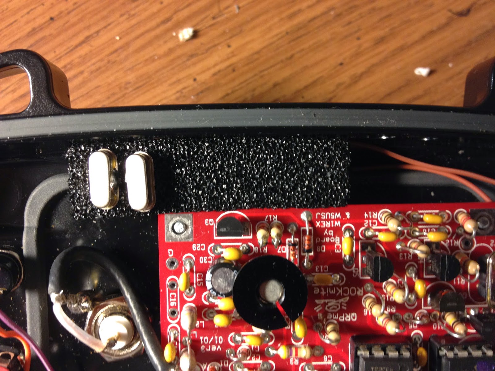
I put foam on the top just because. Notice that there is the strip of foam wedged in between the case and the board. This is the strip that came with the RM. I am going to try to find a longer strip that goes all the way across the case so that I could have an assortment of freqs to put in. Also I added the middle ground tab to each of these so that I can switch them out easily.
A little closer pic. The stuff on the right side of the picture is just caulking. The case is kind of thick so I was not able to get the headphone jack and key jack far enough through to screw them into the case. I used the caulking to hold them in place. It is nice because they are flush with the case as you can see below. I may have to come up with a better method as it is a little "spongy" feeling when inserting the plug...but it works...for now.
Picture of the case closed up and everything plugged in.

Unplugged. I mounted everything on one side so that I can set it flat and plug everything in.


Close up of the crystal foam. Many frequencies will be available. Right now it is only 14.060 and 14.050

Closer on the Caulking and board.

Closer view on the opposite side of the case.


Here is a picture of the Otterbox hanging on the wall. I like the rubber strap as I can hang the RM20 from my bag, tree, or anything else nearby and plug everything in to keep it off the ground and make the conncectors face forward instead of up if I want to.
This was something that I just had laying around and decided to try to use to mount the RM20. I like it because it is a sturdy plastic container that gives me plenty of room for my big fingers to work! I conntected the RM20 up to an antenna, checked all UC voltages and everything seems to work well. I may have this out on the next SOTA activation and give it a try.

Feel free to send me comments / suggetstions / or other ideas about this box. I am going to build a 30m kit her soon and may look at using the same idea. This worked out pretty well.

Thanks for reading.

Matt
KF7PXT

Tuesday, June 10, 2014

Lightning Peak (W7W/SO-021) SOTA

On 8 June Peyton and I decided to go out and try a peak that there was not much information on. Trip reports were few and far between and not detailed. So i took the information that I could find and Peyton and I headed off. We woke up about 0430 and got ready and headed out. When we reached the TH there were no other people there so the parking was all to ourselves. There is room for 3 or 4 cars to park right at the TH and if this is not available then there is more area about 1/2 mile back with plenty of room. We made our way up the Copper Creek trail No. 876 which as a nice stream, old copper mines and nice old growth scenery. They trail is well maintained and clear for the whole trip up to the ridge. After getting to the ridge we hung a left, heading South, on a faint trail heading towards the summit. This ridge trail is rough with some climbing involved with the possibility of falls. I think Peyton is just old enough for me to give it a try. Once the ridge opened up I could immediately see that there was a good bit of snow still in the slide that would have to be navigated to get to the summit. This peak would have to wait for another day. Peyton and I pulled out our breakfast and decided that there would be no better place to eat. I pulled out my HT and decided that I would try to contact my XYL in Olympia and with success I was able to reach her on 147.36 on the OARS repeater, even with the summit between us. Peyton and I finished our breakfast and took some pictures and started making our way back down the trail. After all we did have a plan to head to Point Defiance Zoo and Aquarium with the rest of the family. This trail to the ridge is a good hike that will take the wind out of you and after the ridge it will test you for sure. If and when I do this summit I am thinking that the kids may have to stay at home. To much stress on me worrying about me and the kids falling!


Cell Signal: 
No signal up to the ridge.

Repeaters:
I was able to get into the OARS (Olympia Amateur Radio Society) repeater on 147.36 mhz, 103.5 PL with full quieting.


 Radio working conditions: 
Uknown

Trail Conditions
The Copper creek trail is in great condition but steep. The ridge trail to Lightening Peak is faint and a class 3 climb at times. The summit looked to have a good deal of shale and is probably not navigable without ice axe / crampons until well into July.
Weather: 
Great weather today!

Fees:
None

EVERYTRAIL ROUTE

http://www.everytrail.com/view_trip.php?trip_id=2814236
Setup: 
PFR3 with 1800 m/ah LiPo - http://www.qrpkits.com/pfr3.html
AME Porta Paddle II - http://www.americanmorse.com/portapaddle.htm I am back to the Porta Paddle now. I took it apart and cleaned it up and it is working well. The Te-Ne-Ke is still in the pack as a back up. (This is what I had with me if I would have activated)

Contacts: 

None

Thanks to everyone that was patiently waiting for me to activate. Lack of cell signal and planning did not allow me to update SOTAwatch. If I would have talked to my XYL prior I could have had her send an update. I also could have done a little better planning and contacted Mark (K7NEW) using IRLP and given him an update. I will be better prepared in the future.


Next weekend there is a plan to do a few summits. These are more predictable and have been previously activated.

Thanks again