Recent SOTA Activations

Showing posts with label Geocache on Summit. Show all posts

Friday, August 2, 2019

Doris Mountain (W7M/FN-133) SOTA Activation


My kids acting crazy and moving during the panoramic picture...looks pretty cool though. 

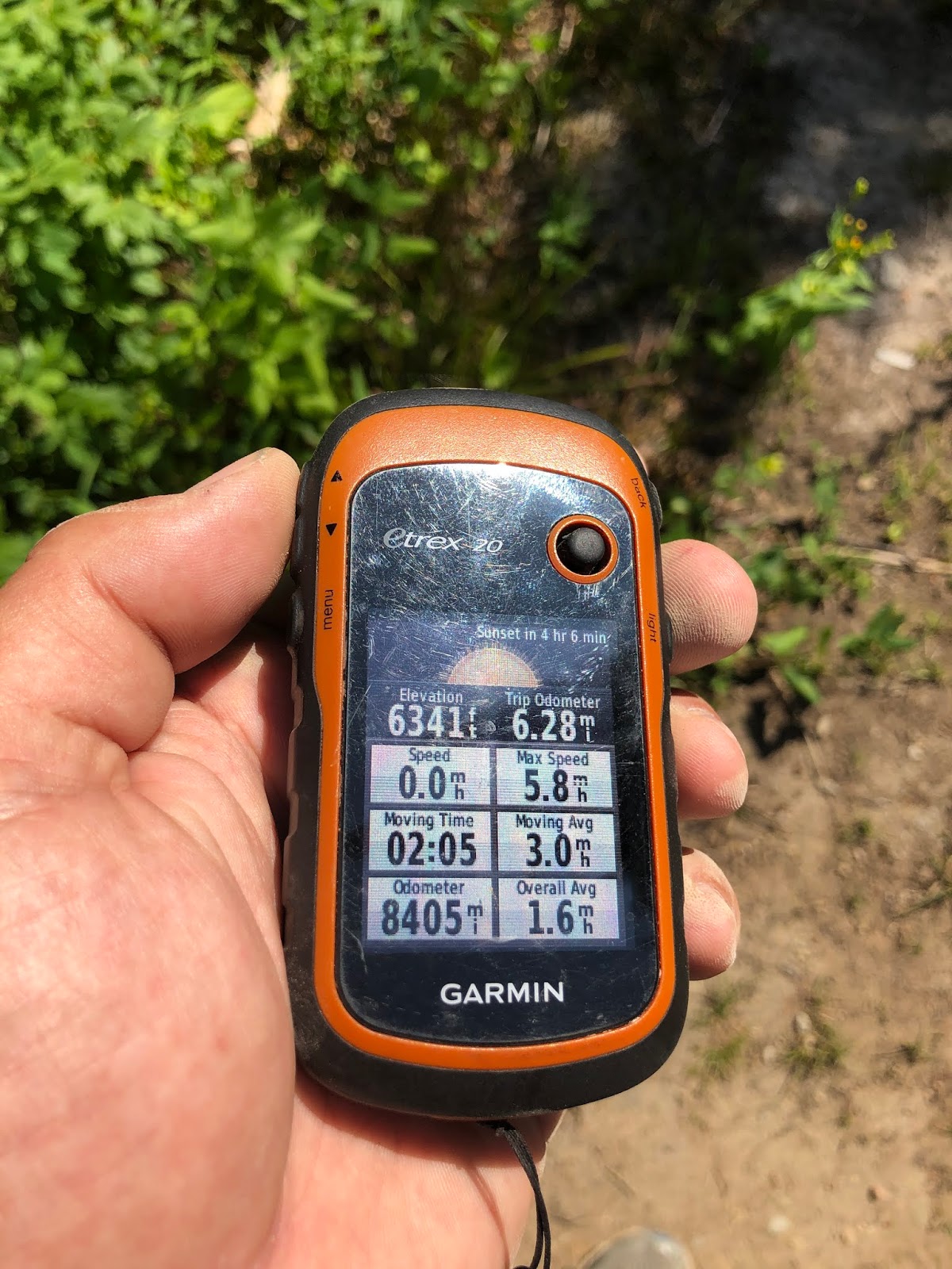
We hiked Doris Mountain on 8/2/2019. I was acquainted with this hike as we had done it on June 15th, but were not able to gain the summit because of deep snow. This time Lily, Colten and I made the trip and it went quickly. We left the house a little after 9 in the morning and arrived at the trailhead just before 11. We did not return back home until after 5. Our actual hiking time was only 2 hours and 5 minutes as can be seen by the GPS below. The rest of the time was spent at the lakes and on the summit. We stopped at the 2nd lake on the way up and the upper most lake on the way down. The cool water was great for a swim. We also spent a couple hours on the summit enjoying the sun, making videos, eating lunch, and doing some Summits on the Air. 

There is the remnants of an old fire lookout at the summit but not much is there...the nail that came through my seat cushion reminded me of the past!

There is now a geocache on the summit...give it a few days to post. It is a small container right now but I am going to swap it out for an ammo can on the next trip. 

Bring your dog with you. Most of the trip is in the shade and there is plenty of water along the way. After you gain the summit ridge there is not much shade though. There are some small trees in the activation area that provide a little bit of shade. 

Cell Signal: 

Verizon: I had signal off and on while hiking up but the signal was strong while on the summit. 

Trail Conditions:

The trail is in great condition. It is much better then it was the last time that we were out there. I made an attempt at the summit on June 15th but there was still to much snow on the North East side of the summit to get to the top. The trail starts out by dropping down a few hundred feet and then starts to climb again up to the lakes. This low ground can be full of water and make it difficult to follow the trail if done to early. It was a complete swamp on June 15th when we did it. We were wading through water that was over knee deep. The climb to the lakes is relatively gentle and a nice stroll in the woods. There is a ton of fish (likely cutthroat and brook trout) in the 2nd lake. I would bet they are in the others also. After the lake it gets steeper and then once you gain the ridge it will get the blood pumping to the summit. 

Equipment:
Elecraft KX2, Home brew 20m dipole, Yaesu VX-6. 

APRS:
Did not use APRS today. The last time that I was in this area I was getting my locations out at the lake. I guarantee that there would be no issues with using APRS...I forgot my Kenwood on the charger at the house. 

GPS Tracks:
Driving GPS Tracks

This starts from where I left hungry horse road. 11.6 miles on the road to the trail head...seems like forever...keep driving.

Driving Directions:
Drive East on HWY 2 out of Columbia Falls. After passing through the town of Hungry Horse turn South to the Hungry Horse Dam. Drive about 6 miles and turn right to Doris Ridge. Follow this gravel road 11.6 miles to the end and the trail head. Plan on about 45 min. to make the 11 mile drive to the TH.

Log:
As always I appreciate all the chasers! Sometimes I am not the best at CW but I love doing it. It was great to hear familiar voices today and I hope to be more frequent for the rest of the summer.

Hitting the upper lake on the way down. This lake was great for a after hike swim!


I designated my daughter Lily to get Pictures. She got some really neat ones. 

A picture from the summit of 2 of the three lakes. The trail goes right by all of these lakes.


There was a lot of bees and horse flies. They left us alone mostly. There was enough breeze in the summit to keep them away. Later the wind calmed down and they were everywhere. 


This was back at the truck and for the Total Trip. 6.28 miles (even with detours).


Elevation and trip distance at the summit. 


Sunday, July 22, 2018

Big Arm Point (W7M/LM-168) SOTA Activation


On Friday 16 March Kimber and I were making a trip to Missoula to pick up my daughter. I decided that it had been a while since I had the radio out and wanted to enjoy the good weather that we were having. I made a decision not to post an alert for this summit as I did not know if it would actually happen, depending on the road conditions.  I also  knew that I would have cell signal to self spot, I had been up on this summit 2 times prior. This summit is a drive up as there is TV and other misc. towers at the top and they keep it plowed most of the time. There is a Dozer at the bottom of the hill that I presume is there to keep the road open in the winter. Even though they keep this road plowed it can still be very bad at times and most of the winter would still probably require chains to get to the top. Mid winter I took the expedition up there with no chains and was in 4wd for the entire trip. There was a couple shady times that I would have preferred chains for traction. There are sections that warm up in the sun and create a sheet of ice that can cause you sliding towards the edge...which at time is very steep. In the summer about any car can make it to the top with some easy driving and maneuver around some larger rocks. I had my Subaru Impreza outback up there last summer. Today I was able to drive most of the way in 2 wheel drive but periodically put the Expedition in 4 wd in order to get a little more traction on the steep icy spots.


Cell Signal: 
I use Verizon and had great cell phone signal from the summit. 

Trail Conditions
This is a drive up and on a gravel road to the summit. I parked on the second to last switchback and walked the rest of the way to the summit. 

Fees:
This area requires a tribal use permit for non-tribal members. You can pick these up at the Walmart in Polson or at Ronan Sports and Western. 

APRS:
Did not use APRS today.

GPS Tracks:

https://www.dropbox.com/s/2xiufzxtexvn5xr/Big%20arm%20point%20gpx%20file.gpx?dl=0

This link will take you too my driving tracks from where I parked to HWY 93. If there is an issue with the link let me know and I will try and figure it out. 


Driving Directions:
HWY 93 just north of Polson, MT will take you to where my GPS tracks start. Link above.

Summit information and resources used for planning

I use this free website to estimate distances of new trails.

Here is one of my secrets!!! Even if you don't do geocaching take a look at the map. If you manipulate it right up can see every summit out there. If there is a geocache at the top, there is a way to get there. Sometimes if you click on the cache it will even give detailed directions to get there and some good pictures.

Here is an example of some decent directions learned from a geocache. The information was out dated but much of the time it is not.

I link to this site from my blog and from my blog to this site. This site is great because it posts the necessary information straight to the Summit Page.

http://www.cqgma.net/mvs/index.php
Adventure Radio Map View - I like this map as a way to see the summits. It seems more user friendly with filters then the SOTA mapping software.

http://www.nohrsc.noaa.gov/interactive/html/map.html
NOHRSC Interactive Snow Information - This is a great tool to see where the snow levels are and what they have looked like in the past on certain dates.

http://www.gpsvisualizer.com/draw/
Put in a route in this site and it will give you a gps file for the information you provide. This works if you want to draw and upload a route into your GPS for use on the trail.


4590 (W7M/FN-235) SOTA Activation


My wife and I made the 5.8 mile R/T hike up to Point 4590. This is a great hike in the Kalispell area and gives way to great views as can be seen from below. There is also a trail that continues on down to the lake as seen from the map below.  The trail has been well maintained. We have been to the area now on two different occasions with not many people there. Today we ran into a group of two hikers and a mountain biker came to the top while we were up there. This is a fairly long hike for a 1 Point SOTA summit but if you are in it for more then SOTA it is a great choice. For those of you that do Geocaching there is also a geocache just off the trail and before the summit. The view from below in only about 30 ft off of the summit so is well within the activation area. The summit has a good amount of trees and there is not much of a view. This summit is probably not a good choice for those collecting points but it is a good hike with a great view...and worth the hike to be the first to activate.  


I tracked our hike with my Garmin on the way up. The GPX tracks can be found here: https://www.dropbox.com/s/ym8gatbu9kjgilm/Track_2018-07-21%20135244.gpx?dl=0
Forest Service Rd. 2924 Takes you to the Trailhead. You can drive most any vehicle to the TH during the summer months. There are a few rutted areas but I think that if you are careful that you can drive through them in any vehicle.

Driving GPS Tracks (Click Here)

I spent a good deal of time trying to Call and also tried 17m SSB, 20m CW, 40m SSB. With no luck. Not sure what was going on today.


Equipment:
Elecraft KX2 with KXPD2 and internal battery. MP1 Super Antenna, Kenwood TH-D72 for 2m and APRS.

Cell Signal(Verizon): 
I use had decent cell phone signal from the summit. I spotted a few times using SOTA Goat and was able to spot with out any issues. LTE/3G signal most of the time.

Trail Conditions
5.8 Miles on a well maintained single track trail. Shared with Horses, Bikers, and Hikers.

Fees:
None

APRS (Kenwood TH-D72):
I did my initial spot using APRS. I like to keep proficient in these uses. It was a good thing that I did it as it took some getting used to again. 

Driving Directions:
From Kalispell, Farm to Market Road, Tally lake Road, FR2924

Band Conditions:
I was not able to work near as many stations as I am used to. Band conditions were not that great but I was able to get a few contacts. Two of my normal contacts N4EX and W0MNA were not able to make the contact. I could here them fine but was not able to complete the contact on my end.

Summit information and resources used for planning

I use this app to estimate distances of new trails.

Here is one of my secrets!!! Even if you don't do geocaching take a look at the map. If you manipulate it right up can see every summit out there. If there is a geocache at the top, there is a way to get there. Sometimes if you click on the cache it will even give detailed directions to get there and some good pictures.

Here is an example of some decent directions learned from a geocache. The information was out dated but much of the time it is not.

http://www.cqgma.net/mvs/index.php
Adventure Radio Map View - I like this map as a way to see the summits. It seems more user friendly with filters then the SOTA mapping software.

http://www.nohrsc.noaa.gov/interactive/html/map.html
NOHRSC Interactive Snow Information - This is a great tool to see where the snow levels are and what they have looked like in the past on certain dates.

http://www.gpsvisualizer.com/draw/
Put in a route in this site and it will give you a gps file for the information you provide. This works if you want to draw and upload a route into your GPS for use on the trail.